My review
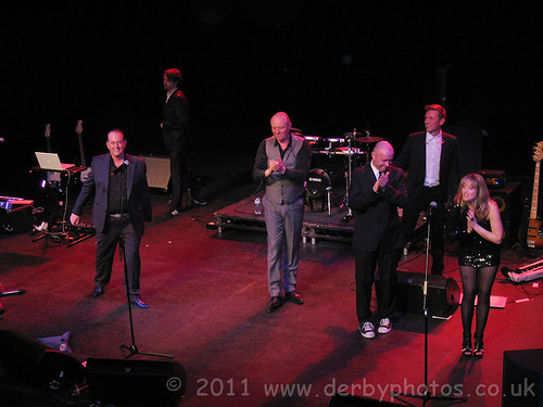
Last night 80s legends Heaven 17 performed their Penthouse and Pavement gig at Buxton Opera House.
The support act was Go Go Bot.
My favourite track they did was Temptation which had an amzing over the top start to it.
Also a track that you never expected was a cover of Party Fears Two by The Associates which was performed stunningly.
My photograph of Heaven 17 on stage at Buxton Opera House last night
Martyn Ware on keyboards, Glenn Gregory lead singer, Joel Farland on Drums, Julian Crampton on Bass, Asa Bennett on Guitar and aamzing backing vocals by Billie Godfrey.
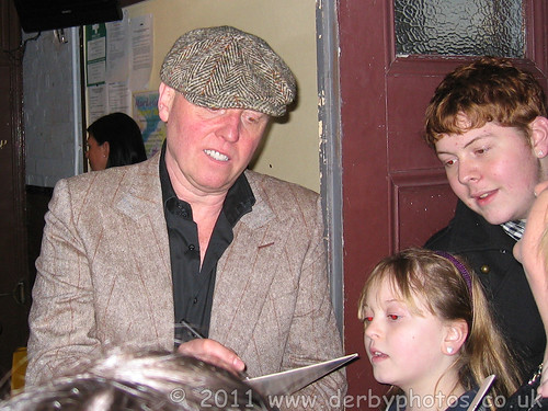
Heaven 17 signing Autographs
The band members were signing autographs outside the stage door afterwards
as you can see here :
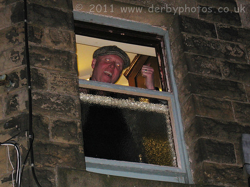
The moment Glenn Gregory turned into Victor Meldrew !!!
This was a very funny and surreal moment in Buxton last night.
It was 11:43pm and the members of Heaven17 had been outside the stage door signing autographs for fans for a while and Glenn Gregory had gone back in, leaving just Martyn Ware outside.
Suddenly the window opened on the floor above the stage door and Glenn appeared in flat cap and said "Keep the noise down, theres people that have got to get up for work in the morning you know", this was met by lots of laughter from the crowd.
If you were there, post a comment to this blog post.
What did you think to the support act Go Go Bot ?
Cheers
Andy
Monday, February 28, 2011
Saturday, February 26, 2011
The Derby Friargate Line Route map. (GNR Derbyshire and Staffordshire Extension.)
A few years ago I created a map showing the route of the former GNR line through Friar Gate. Over the last week I have been redoing this route map using all the latest web developments and knowledge I've gained to make a greater detailed map than ever before.
Large sections of the route have been or are being, converted to cycle paths and walkways and adopted by Sustrans.
The GNR Derbyshire and Staffordshire Extension route or Derby Friar Gate Line as its often referred to locally was a "back line"that opened in 1878 and ran from Nottingham through Derby (over Friar Gate Bridge) and to Egginton where it joined the North Staffordshire Railway. This line closed in 1964.
On my map I have traced the entire original route of the Friar Gate Line from its junction at Egginton all the way to Nottingham. Along the way I have marked on the locations of the all the GNR railway stations that served the Friar Gate line.
The GNR Friar Gate Line Serving stations (Have I missed any?)
Egginton Junction, Etwall Railway Station, Mickleover Railway Station, Derby Friar Gate Railway Station, Awsworth Railway Station, West Hallam Railway Station, Kimberley East Railway Station, Daybrook Railway Station, Basford North Railway Station, Gedling Railway Station and Netherfield Railway Station.
I have also marked the tunnels at Mapperley, Mickleover and Morley.
Using the Satellite mapping function in Google Maps you can clearly see certain sections of the line.
I have also used Google Streetview in many locations along the route to identify road bridges and paths. Sometimes even though the railway line has gone, the bridge over it remains in place.
Some of the markers I have placed in my map have small photographs in them, click on them to view a larger version. These photographs were taken by Flickr photographers.
If YOU have any photographs of things along this route that I have not included then please get in touch so I can add them.
I have put a lot of time and effort into making sure my route path and markers are correctly positioned but in some areas such as Daybrook I may be off slightly, please let me know if this is the case. In those areas where there was no clear route using the Satellite map I had to guess by using bridges and stations either side for reference combined with some old maps of the route.
I hope you find my Friar Gate Line Route map of interest, perhaps you will learn something from it that you did not know before.
My Map :
The Derby Friargate Line Route map. (GNR Derbyshire and Staffordshire Extension.)
I have provided several quick links that will allow you to zoom in on stations etc. Simply use your mouse to drag the map around to follow the original route of the railway lines (marked with a blue line).
Some of the books I used for reference :
Friargate Line: Derby and the Great Northern Railway
Lost Railways of Derbyshire
Lost Railways of Nottinghamshire
There are lots of books on this subject but quite a few are out of print but you may find one on ebay.
Here is an embedded map of the complete Friar Gate Line route showing all markers :
View The Derby Friargate Line Route. (aka GNR Derbyshire and Staffordshire Extension) in a larger map
Thanks
Andy
Thursday, February 17, 2011
Music Video - Vernon Street by The Ash Lovelies.
I thought I would share this great song with you, I found it because it was added as a video response to my Derby night time video "Staggered time shift time-lapse Night Driving experiment" probably because I list Vernon Street in the description. The Vernon Street in this song is actually in America but what the hell this song is great. What do you think?
The singers voice reminds me of Lloyd Cole .
The song was written by: Lou Black; Matt Rutherford; Dominic Hook; Tanisha Paige; Jeff Raudebaugh; Bryan Bowman; Avelynn Mitra
Music Video : The Ash Lovelies - Vernon Street
Wnat to hear more of their music check out their myspace page.
The CD has since been released and is available to buy in the UK -
Hope you enjoy it.
Andy
Wednesday, February 16, 2011
Belper Farmers Market, second Saturday of every month. Dates for 2011
Belper Farmers' Market takes place on the second Saturday of every month.
The market runs from 9am to 2pm on Belper Market Place.
Belper Farmers Market :
The next Belper Farmers Market will take place on Saturday, 12th March 2011
Dates in 2011 for the Belper Farmers Market.
Saturday February 12th (You've just missed that one!)
Saturday March 12th 2011
Saturday April 9th 2011
Saturday May 14th 2011
Saturday June 11th 2011
Saturday July 9th 2011
Saturday August 13th 2011
Saturday September 10th 2011
Saturday October 8th 2011
Saturday November 12th 2011
Saturday December 10th 2011
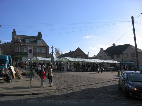
Belper Market Place is located at the very top of King Street where it meets the A609. As you can see in
my photograph of the Farmers Market, the market stalls occupy the top corner area of the Market Place.
Heage Windmill always have a stall here, selling freshly ground flour from the windmill. Some other stalls that
are often here are ones selling local cheeses, meats, locally brewed speciality beers etc.
If you are arriving in Belper by car then there are several car parks you can use for the Farmers Market, The Town is not very big so its not far to walk to most places. There is a car park next to the Co-Op off Strutt Street which is £2 for 2 hours. There are public toilets just around the corner from this car park.
If you don't want to walk up the steep incline of King Street then you could park in the car park off Green Lane. (see my map).
At the top corner of the Farmers Market is a church hall with crafts on show, Here you can also get a free cup of Tea and a biscuit on the Market days.
If you want a cheap but very tasty meal then I can recommend Poppy's Cafe on Chapel Street next to the bus station.
At the last Farmers Market I bought an amzing Rhubarb Pie that was the best Rhubarb pie I had ever tasted.
It was on a stall by Lime Tree Pantry. Looks like you can buy their pies on-line
http://www.limetreepantry.com/
Map showing location of Belper Farmers Market:
View Belper Farmers Market. in a larger map
This market is run by Belper Town Council, contact them if you would like to have a stall at this market.
Here are the dates for the next few months :
Tuesday, February 15, 2011
Ford Street and Stafford Street become two-way as of today, A Big change for Derby motorists.
As of today (Friday 18th Februay) the Connecting Derby work has a major effect to how you drive around Derby, because Ford Street and Stafford Street become two-way. Temporary traffic signals will continue to operate at the Uttoxeter New Road roundabout to ensure that traffic flow remains effective.
Traffic travelling to the A52, city centre, Cock Pitt and Pentagon Island will be directed to use this route rather than the traditional route through Curzon Street and Cheapside.
I see Google Maps have already updated their map to show this new road layout around Stafford Street.
It even shows the new Mercian Way thats not due to open for a few weeks.
The "Connecting Derby" NEW Road Layout on Google Maps :
View Larger Map
If you want to know more about Connecting Derby then look at their latest news letter this shows all the latest news including a full detailed map of the new road layout.
I dare say until people update their Sat Navs this new road layout is going to cause chaos for people, especially people who have never driven around Derby before.
There is a detailed description on the Derby City Council website about what Connecting Derby will consist of: What is Connecting Derby.
If you have forgotten what Derby Inner Ring Road used to look like before all of this work then take a drive around it in my video - Video of Derby Inner Ring Road before connecting Derby.
UPDATE: As of 7:15 this morning the new road was NOT open so perhaps the Council have got the date wrong? It looked like there was a few more hours of tarmac work needed on Stafford Street before it could be opened to traffic.
UPDATE: Friday 18th February, finally this bit of road IS open but its still not finished off as there are parts of it that have raised iron work. I have just driven on the new bit. I drove down Uttox New road towards town and turned left down Stafford Street towards Ford Street where I turned LEFT onto Friar Gate towards Ashbourne Road.
Andy
Heaven 17 to play Buxton Opera House 27 February.
Are you in your 40s, if so I'm sure you will remember the 80's band Heaven 17 who had lots of hits such as Temptation, come live with me and Let me go. Well here is a chance to see them again in a couple of weeks at Buxton Opera house in Derbyshire.
Penthouse & Pavement, with its singles We Don’t Need This Fascist Groove Thang and Play To WinThe Luxury Gap, featuring the hit singles Temptation, Come Live With Me, Crushed by the Wheels of Industry and Let Me Go and further success followed with tracks including This Is Mine and Sunset Now. was followed by the hugely successful Now, with core line-up of Martyn Ware and Glenn Gregory augmented by the soaring backing vocals of Billie Godfrey, Heaven 17 are able finally to recreate the studio-based sounds of their albums on the live stage.
Plus support act Go Go Bot.
If you have forgotten what they sounded like, here is a video of a DVD out now :
Also I'm sure you have probably seen them in a recent TV advert for plusnet.
Its says on the ticket "plus support" I wonder who thats going to be?
More info on Heaven 17 :
Heaven 17 at Buxton Opera House.
Heaven 17.
I got my tickets a couple of weeks ago so if you want to go you need to ring up today and get yours. It only cost 65p to get the tickets posted out and no debit card fee to pay ! So nice to be able to get the tickets cheap unlike those ticketmaster ones where they charge silly admin fees etc.
Andy
Tuesday, February 8, 2011
World Wide Panorama - Best of 2010 - Dovedale Stepping Stones.
Regular visitors to my blog may be familiar with my 360x180 degree photography and my submissions on the World Wide Panorama website. The last event closed in January and the theme for this event was "best of 2010" so for my entry I submitted a panorama I took in the middle of Dovedale Stepping Stones.
Click the link here to see my panorama :
Dovedale Stepping Stones panorama.
Check out the other entries around the planet by other VR photographers :
Map of all entries for the Best of 2010 event.
The World Wide Panorama began in March 2004 and has become an ongoing series of events.
Photography takes place on the solstices (longest and shortest days of the year) and equinoxes (day and night of equal length). Photographers all over the world are welcome to participate in the themed events.
Thanks
Andy
Subscribe to:
Posts (Atom)