Following on from last weeks post of a time-lapse drive around the newly completed Derby inner ring road. I have now uploaded a real video of a drive around the loop in a clockwise then anti-clockwise direction. Filmed in H.D. The video camera was mounted right next to my time-lapse camera so you will see the same views as per my other video but at a speed where you can see them better.
The video file I uploaded to YouTube for this was 700Mb, one of the largest files I have ever uploaded.
The video is best watched in 720p mode or at least 480p mode and in full screen. You do need a fast PC and good broadband connection to do this.
The final link (Mercian Way) in Derby's inner ring road was opened on 16th March 2011, marking the completion of major work on the city's £36.2m Connecting Derby scheme.
Thanks
Andy
Showing posts with label Way. Show all posts
Showing posts with label Way. Show all posts
Saturday, April 16, 2011
Saturday, April 9, 2011
New Video : Driving Time-lapse of Derby's completed Inner Ring Road. March 2011
I have finally got around to uploading my video of a time-lapse drive around the now finished Derby Inner Ring Road. I filmed this on Sunday 27th March 2011.
It is made from photographs sequenced so that it looks like video footage.
I have driven it in both clockwise and anti-clockwise directions to give you an idea of how it looks in either direction.
To enjoy my video at its best you need to watch it in Full Screen mode and at 720p (if your PC and broadband can handle that).
The final link (Mercian Way) in Derby's inner ring road was opened on 16th March 2011, marking the completion of major work on the city's £36.2m Connecting Derby scheme.
My Video :
Thanks
Andy
Tuesday, March 15, 2011
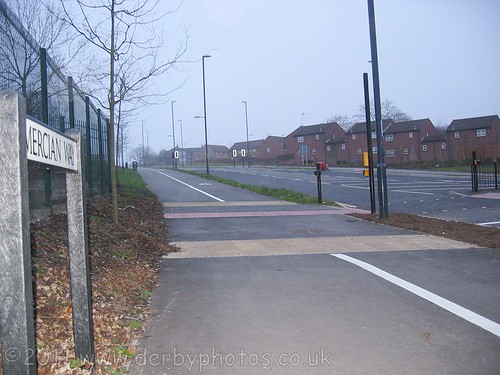
Mercian Way, Final section of Derby's inner ring road will be opened Wednesday 16th March 2011.
Mercian Way will be opened at 1.30pm and will connect the new Stafford Street roundabout with the Burton Road roundabout and Lara Croft Way, which was opened in July 2010.
Once the inner ring road has been open for a bit and settled down I will create a new driving video of it in the same manner as the one I did in 2009 - Video of Derby inner ring road by car.
If you missed my driving video of Lara Croft Way then view that to see where this final section will connect at the top of Babbington Lane.
Photograph of Mercian Way the day before it opens.
View looking up from Abbey Street toward Lara Croft Way.
View looking up from Abbey Street toward Lara Croft Way.
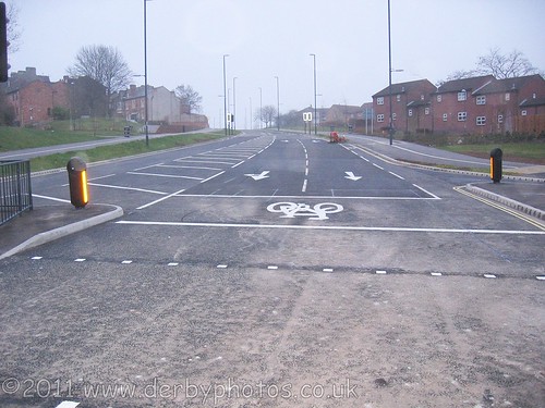
Photograph of Mercian Way the day before it opens.
View looking towards Stafford Street from Abbey Street.
Map showing the final section that opens on Wednesday 16th March :
View Derby inner ring road - Lara Croft Way and Mercian Way. in a larger map
You may remember that Lara Croft Way opened up way back in July 2010, at last we will be able to drive from Friar Gate all the way to it using this new road.
Thanks
Andy
Once the inner ring road has been open for a bit and settled down I will create a new driving video of it in the same manner as the one I did in 2009 - Video of Derby inner ring road by car.
If you missed my driving video of Lara Croft Way then view that to see where this final section will connect at the top of Babbington Lane.
Photograph of Mercian Way the day before it opens.
View looking up from Abbey Street toward Lara Croft Way.
View looking up from Abbey Street toward Lara Croft Way.
Photograph of Mercian Way the day before it opens.
View looking towards Stafford Street from Abbey Street.
Map showing the final section that opens on Wednesday 16th March :
View Derby inner ring road - Lara Croft Way and Mercian Way. in a larger map
You may remember that Lara Croft Way opened up way back in July 2010, at last we will be able to drive from Friar Gate all the way to it using this new road.
Thanks
Andy
Tuesday, February 15, 2011
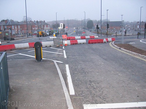
Ford Street and Stafford Street become two-way as of today, A Big change for Derby motorists.
As of today (Friday 18th Februay) the Connecting Derby work has a major effect to how you drive around Derby, because Ford Street and Stafford Street become two-way. Temporary traffic signals will continue to operate at the Uttoxeter New Road roundabout to ensure that traffic flow remains effective.
Traffic travelling to the A52, city centre, Cock Pitt and Pentagon Island will be directed to use this route rather than the traditional route through Curzon Street and Cheapside.
I see Google Maps have already updated their map to show this new road layout around Stafford Street.
It even shows the new Mercian Way thats not due to open for a few weeks.
The "Connecting Derby" NEW Road Layout on Google Maps :
View Larger Map
If you want to know more about Connecting Derby then look at their latest news letter this shows all the latest news including a full detailed map of the new road layout.
I dare say until people update their Sat Navs this new road layout is going to cause chaos for people, especially people who have never driven around Derby before.
There is a detailed description on the Derby City Council website about what Connecting Derby will consist of: What is Connecting Derby.
If you have forgotten what Derby Inner Ring Road used to look like before all of this work then take a drive around it in my video - Video of Derby Inner Ring Road before connecting Derby.
UPDATE: As of 7:15 this morning the new road was NOT open so perhaps the Council have got the date wrong? It looked like there was a few more hours of tarmac work needed on Stafford Street before it could be opened to traffic.
UPDATE: Friday 18th February, finally this bit of road IS open but its still not finished off as there are parts of it that have raised iron work. I have just driven on the new bit. I drove down Uttox New road towards town and turned left down Stafford Street towards Ford Street where I turned LEFT onto Friar Gate towards Ashbourne Road.
Andy
Thursday, July 29, 2010
Video of Lara Croft Way, Derby Inner Ring Road and new road layouts.
This is the latest video in my “Derby Streets by car in HD” series, this one is a short car journey that encompasses all of the latest new roads and road changes relating to the Connecting Derby project on Derby Inner Ring Road.
These Roads are either newly opened or one way roads that have become two way.
Lara Croft Way is a newly constructed road where as the parts of Normanton Road and Burton Road were previously one way roads, these are now two way roads.
Lara Croft Way opened in two stages one direction on 11th May 2010 and the other way on 27th July 2010.
Because these are new roads they are not on Google Maps or Google Streetview.
However I have generated a detailed map showing the new roads and how they connect to form the new Derby inner ring road. I have also made a 360 degree interactive panoramic photograph near the traffic island at Lara Croft Way (a-la Google Streetview).
Also the driving video I have made here will allow you to see how it all connects together. This video was filmed at 7am on Wednesday 28th July 2010 which is why there is little traffic on the roads, giving a better view than queuing traffic!
Lara Croft Way Driving video
If you have a fast broadband connection and high-end PC then best to view in 720p HD and fullscreen.
The driving Video Route Details.
The drive starts on Burton Road (A5250) heading into Derby. On the right side you can see Mount Street which is where (up until 27/07/2010) you would rejoin the inner ring road in the clockwise direction. As you can see this section of Burton Road is now two way.
On the right we pass The Duke of York Pub.
We now arrive at the new Round-a-bout, this connects the following roads.
Burton Road (two way)
Mercian Way (not yet open), the next section of the inner ring road.
Green Lane (one way)
Babington Lane (one way)
Lara Croft Way (two way)
Normanton Road (two way)
At this round-a-bout I take the 4th exit onto Lara Croft Way, This is a brand new road which forms part of the final link of Derby Inner Ring Road. Lara Croft Way cuts through former streets such as Sacheverel Street and Wilmot Street. Lara Croft Way then connects to the existing round-a-bout on Osmaston Road.
The Osmaston Road round-a-bout connects the following roads:
Lara Croft Way (two way)
Osmaston Road A514 towards the Spot (two way)
Bradshaw Way A601, (two way) Existing inner ring road.
Osmaston Road A514 (two way) towards Allenton.
Charnwood Street (one way) now closed off.
Leopold Street (one way) now closed off.
Lara Croft Way
At the Osmaston Road round-a-bout I take the 4th exit which takes me back up Lara Croft Way in the other direction. At this round-a-bout I take left into Normanton Road. This section of Normanton Road used to be one way, as you can see its now two way. On the left is Leopold Street which is the way you used to go to get onto the inner ring road, Leopold Street was closed off on Tuesday 11th May 2010 when Lara Croft Way opened up in one direction only.
At the Charnwood Street junction you would normally see inner ring road traffic coming from the left but Charnwood Street is now blocked off at the Osmaston Road end.
Here on Normanton Road I turn right into Southgate Retail Park (Lidl) and do a u-turn in the entrance and head back onto Normanton Road towards Derby centre.
Notice here on the left that the slip road leading to Mill Hill Lane has been closed off, instead Normanton Road has become two way. So as of July 27th the Mill Hill Lane/Mount Street/Burton Road/Normanton Road loop part of the Old Inner Ring road is now no longer needed.
You are now allowed to drive Down Normanton Road in the other direction.
At the round-a-bout I turn left onto Burton Road which is now two way. It feels very strange being able to drive down this bit of Burton Road in this direction after all the years of it being one way.
Here we rejoin Burton Road where Mount Street used to join with it.
Detailed Driving Route Map:
View Lara Croft Way, Derby Inner Ring Road Driving video Route in a larger map
On the first day of these new roads opening I was stuck in horrendous queues of traffic but I think once the Derby City council have adjusted the traffic light sequences at Lara Croft Way then this new section of the inner ring road will help a lot. I look forward to seeing the remaining section of the inner ring road opening between Lara Croft Way and Ford Street, this will complete Derby Inner Ring Road
Hope you enjoyed this little trip.
Andy
Tuesday, July 27, 2010
Lara Croft Way, Derby Now open. 360 Degree Virtual Reality Photograph of the new road.
As of today, Tuesday 27th July 2010, Lara Croft Way was fully open in both directions.
Here is a 360 degree VR photography I took of the new road. Just like a Google Streetview view but better, using complete Spherical VR photograph 360 x 180 degrees.
The view you can see in my photograph is the new round-a-bout at the top of Babington Lane. This traffic island joins Lara Croft Way, Burton Road, Mercian Way (opening later in 2010), Green Lane and Babington Lane.
Use the mouse to drag the view around...
Lara Croft Way 360 degree V.R. Photograph.
If you would like to see a high resolution, fullscreen version of my VR photograph of Lara Croft Way then click the link here :
High Resolution 360 degree view of Lara Croft Way, Derby.
I have made it so it auto-resets the view, so if you zoom fully all the way in and release the mouse button then after 4 seconds it will zoom back out again.
As well as Lara Croft Way being opened up fully today, Burton Road between this round-a-bout and Mount Street became two-way. It felt very strange driving in front of The Duke of York pub "the wrong way" after all these years.
Also Normaton Road between the new round-a-bout and Melbourne Street became two-way, thus meaning no more having to crive around Mill Hill Lane and Mount Street.
Unfortunately I think the traffic light timmings need some serious looking at because I tried the new route and it took 25 mins to get from Osmaston Road to Burton Road because the lights near Leopold street were only staying green for 10 seconds.
Lara Croft Way Map.
Here is a detailed map showing the exact location of Lara Croft Way in Derby, Click on the link below the map if you want a larger version you can print out :
View Derby inner ring road - Lara Croft Way and Mercian Way. in a larger map
The next road to open will hopefully be Mercian Way which connects to this round-a-bout and leads down to Abbey Street.
Andy
Monday, May 10, 2010
Lara Croft Way opens Tuesday 11th May, part of Derby inner ring road.

Lara Croft Way opens to traffic on Tuesday 11th May 2010, This new section of Derby Inner Ring Road was named Lara Croft Way after an online poll by Derby City Council. The decision was revealed by Derby City Council on Friday, February 26, 2010.
This section of the inner ring road is 942 foot (287meters) in length. and connects the top of Babington Lane, Green Lane, Normanton Road and Burton Road (via a new roundabout) and then travels though the former streets of Sacheveral Street and Wilmot Street and connects at an exisiting roundabout at Osmaston Road, Leopold Street, Bradshaw Way. Once Mercian Way opens later in the year it will connect with the Lara Croft Way roundabout at the top of Babington Lane.
Lara Croft Way is only open in one direction at the moment so its currently not possible to drive from the Osmaston Road roundabout to the Babington Lane Roundabout. The outbound section of Lara Croft Way is due to open in two months. Charnwood Street will then become a cul-de-sac.
I was one of the first few to drive along Lara Croft Way on Tuesday morning at 7:10am, It felt strange being able to cut out the bit down Normanton Road and Leopold Street, It was about 3 minutes quicker than going the old route. At busy times it would probably save even more time than that. All we need now is for Mercian Way to open and that will help make it quicker still.
Here is a map showing the exact route of Lara Croft Way in Derby :
View Derby inner ring road - Lara Croft Way and Mercian Way. in a larger map
Mercian Way will be the next section to open up, looking at how its going I would imagine that the section from the top of Babington Lane down to Abbey Street will be the next to open to traffic.
Friday, March 5, 2010
Lara Croft Way, Derby Inner Ring Road opening soon. With Map location.

UPDATE : Lara Croft way opens 11th May 2010.
This is a photograph I took two hours ago of the soon to open Lara Croft Way which forms part of the final section of Derby inner ring road.
Once its actually open I will post one of driving videos around the new inner ring road. I made a video around the inner ring road before this final section was finished back in July 2009. Watch my driving video here : http://www.youtube.com/watch?v=1nuZ1WGP07U
I have created a detailed map below showing the exact route of the final section of Derby Inner Ring Road with the Lara Croft Way section of it clearly marked.
View Derby inner ring road - Lara Croft Way and Mercian Way. in a larger map
Subscribe to:
Posts (Atom)